
| Valley Stream, NY Weather | |||
|---|---|---|---|
| LAST READING AT TIME: 9:10 AM DATE: July 25 2026 ,Time of next update: 9:20 AM | |||
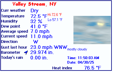
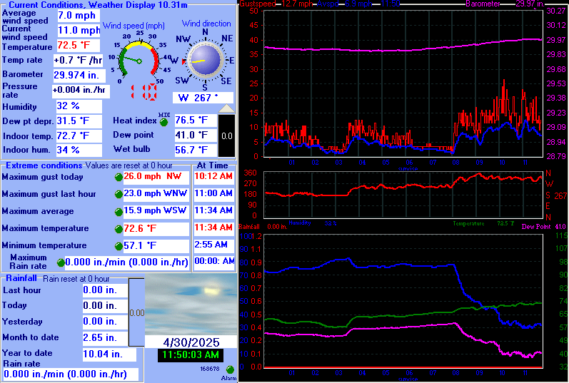
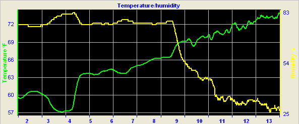
| Current Weather | Dry | Current Temperature | 74.3 °F (23.5°C) (Heat Index 77.0 °F ), Apparent temp 74.8 °F |
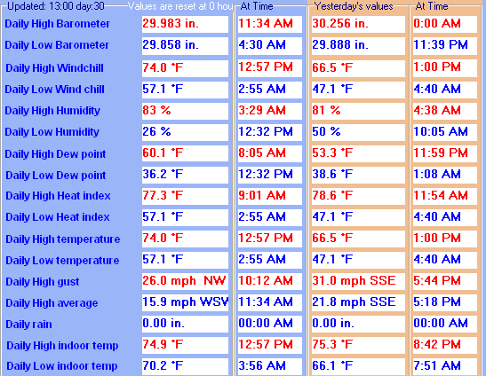
| Maximum Temperature (since midnight) | 74.3 °F at: 9:09 AM | Minimum Temperature (since midnight) | 61.9 °F at: 5:48 AM |
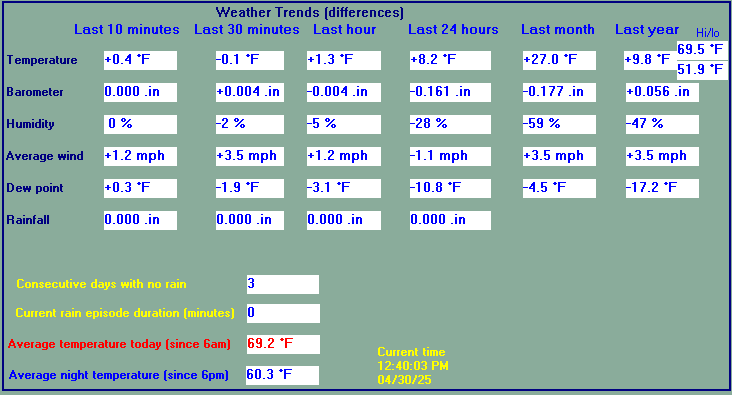
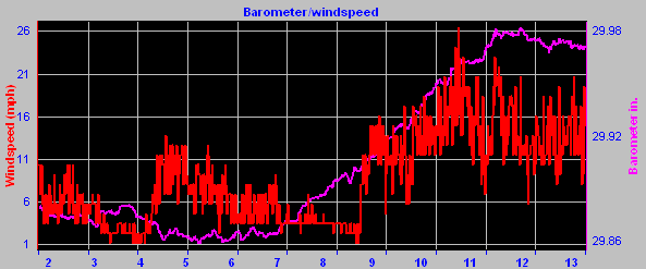
| Average windspeed (ten minute) | 5.2 mph | Wind Direction (ten minute) | NE (38ş) |
| Heat Index | 77.0 °F | Maximum Gust (last hour) | 12.0 mph at: 8:45 AM |
| Maximum Gust (since midnight) | 12.0 mph at: 8:45 AM | Maximum 1 minute average (since midnight) | 9.9 mph at: 8:45 AM |
| Rainfall (last hour) | 0.00 in. (0.0 mm) | Rainfall (since midnight) | 0.00 in. (0.0 mm) --- |
| Rainfall This month | 4.69 in. (119.1 mm) | Rainfall To date this year | 18.25 in. (463.6 mm) |
| Maximum rain per minute (last hour) | 0.00 in/min | Maximum rain per hour (last 6 hours) | 0.00 in/hour |
| Yesterdays rainfall | 0.00 in | DewPoint | 59.0 °F (Wet Bulb :65.1 °F ) |
| Humidity | 59 %, Humidex 81.5 °F | Barometer corrected to msl | 30.137 in. (1020.6 hPa) |
| Pressure change | -0.01 in. (last hour) | Trend | STEADY |
| Pressure change (last 12 hours) | -0.04 in | Pressure change (last 6 hours) | -0.01 in |
| Current Indoor temp. 77.5 °F | |||
| Current Indoor hum. 44 % | |||
Expires:202607252000;;563197
FPUS51 KOKX 250647
ZFPOKX

Zone Forecast Product
National Weather Service New York NY
246 AM EDT Sat Jul 25 2026


NYZ179-252000-
Southern Nassau-
246 AM EDT Sat Jul 25 2026

.TODAY...Sunny. Highs in the lower 80s. Northeast winds 5 to
10 mph, becoming east 10 to 15 mph this afternoon.
.TONIGHT...Clear. Lows in the mid 60s. East winds 5 to 10 mph
with gusts up to 20 mph, becoming northeast after midnight.
.SUNDAY...Sunny. Highs in the lower 80s. Northeast winds around
5 mph, becoming southeast in the afternoon.
.SUNDAY NIGHT...Mostly clear. Lows in the upper 60s. South winds
5 to 10 mph.
.MONDAY...Mostly sunny. Highs in the lower 80s. South winds 10 to
15 mph.
.MONDAY NIGHT...Mostly cloudy with a chance of showers. Lows in
the upper 60s. Chance of rain 50 percent.
.TUESDAY...Showers likely in the morning, then showers with a
chance of thunderstorms in the afternoon. Highs in the lower 80s.
Chance of rain 90 percent.
.TUESDAY NIGHT...Showers with a chance of thunderstorms. Lows in
the upper 60s. Chance of rain 90 percent.
.WEDNESDAY...Partly sunny. A chance of showers. Highs in the
lower 80s. Chance of rain 50 percent.
.WEDNESDAY NIGHT...Mostly cloudy in the evening, then becoming
partly cloudy. A chance of showers. Lows in the upper 60s. Chance
of rain 40 percent.
.THURSDAY...Mostly sunny. Highs in the lower 80s.
.THURSDAY NIGHT...Partly cloudy. Lows in the upper 60s.
.FRIDAY...Sunny. Highs in the lower 80s.

$$


KENNEDY INTERNATIONAL AIRPORT , NY, United States (KJFK) 40-38N 073-46W 9M
Jul 25, 2026 - 08:51 AM EDT / 2026.07.25 1251 UTC
Wind: from the ENE (070 degrees) at 8 MPH (7 KT):0
Visibility: 10 mile(s):0
Sky conditions: mostly cloudy
Temperature: 73.0 F (22.8 C)
Dew Point: 54.0 F (12.2 C)
Relative Humidity: 51%
Pressure (altimeter): 30.15 in. Hg (1020 hPa)
ob: KJFK 251251Z 07007KT 10SM SCT140 BKN250 23/12 A3015 RMK AO2 SLP208 T02280122
cycle: 13
Southern State Parkway Traffic Cam
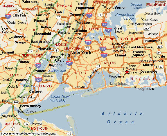
Weather Station Location


Click here for the NOAA report to date for the month

![]()
Use the RELOAD facility on your browser to retrieve the latest data.


Weather station in service since 01/01/2005
Website statistics since 03/05/2025